
Characteristics of Geology in Japan
Next, the geological characteristics and structure in Japan are described below.
Geological map of Japan can be checked on the Internet.
https://gbank.gsj.jp/geonavi/geonavi.php
(Geological Survey of Japan, AIST (ed.). 2015. Seamless digital geological map of Japan 1: 200,000. May 29, 2015 version. Geological Survey of Japan, National Institute of Advanced Industrial Science and Technology.)
Geological map is a color-coded that constitutes the ground depending on the type of rock (not soil) and the age in which it was made. And it shows that the darker the color, the more it represents a rock made in the old age. French geologists write a book called “TERROIR, Role of Geology, Climate, and Culture in the Making of French Wines”, which contains geological map of France. Compared to this Geological Map of France, the geology of Japan is rich in variety, and it can be found that the aspects are completely different. The above-mentioned differences in geology between Japan and France are due to the fact that they are completely different.
You may have known that the crust covering the earth’s surface is made of multiple blocks called “plate”. This plate is constantly moving, and in some fast places it has been moving for more than 10 cm/ year. This is more than three times the speed at which the nail extends. The direction of this movement is different among plates, and a large force is applied at some plate boundaries. Since the Japanese Islands is located at the boundary of the four plates, various forces are applied, and it continues to deform even now.
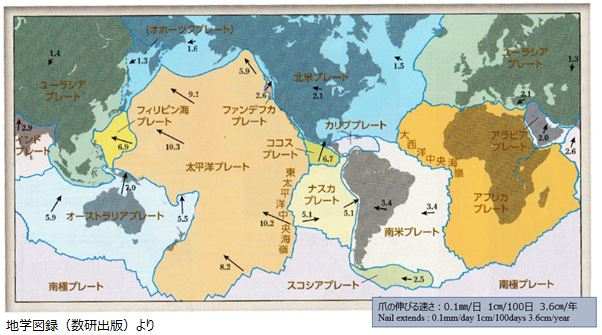
Fig.4 Plates and annual amount of movement (cm/year)
Deformation caused by forces near plate boundaries can appear as earthquakes or volcanic activity. Earthquakes are caused by the impact of destroying pressured crust as ground tremors, so many earthquakes occur along the plate boundary.
Because the oceanic plate is heavier than the continental plate, at the plate boundary, the oceanic plate sinks under the continental plate. Igneous activity is caused by magma generated by the subducting oceanic plate, which carries large amounts of water into deep parts, making it easier for rocks to melt. The eruption is a phenomenon in which liquid magma has a smaller specific gravity rises, reaches the vicinity of the surface of the earth, reacts with groundwater, and spews out to the surface of the earth.
Fig.5 shows plate boundary as a cross-section. As shown in this figure, various types of rocks are formed around the plate boundary (subduction zone).
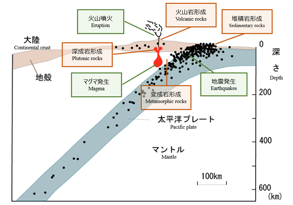
Fig. 5 Various rocks are formed around the plate boundary
The current distribution of plates on Earth is the result of the continent’s many discrete scatterings due to the plate motion that has continued throughout the long history of the Earth.
The geology that constitutes the present Japanese Islands is mainly sedimentary rocks including metamorphic rocks that have been deposited near the plate boundary and pelagic seafloor called “accretionary prism”, and igneous rocks (plutonic rocks and volcanic rocks) made of magma, and traces from about 500 million years ago created by plate movements from the past remain.
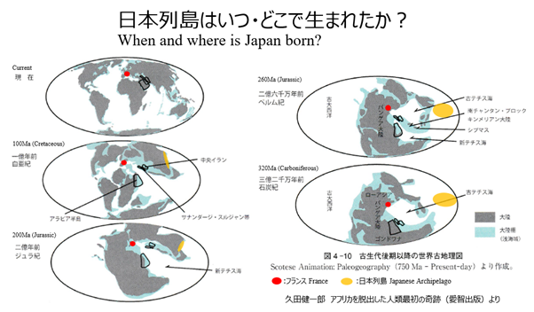
Fig.6 Continents repeatedly separated and scattered